

Virginia has one of the most diverse collections of national park sites of any state in the country. Go for a scenic drive, explore early American history, visit Civil War battlegrounds, or hit the trail for thrilling outdoor recreation. There are countless themes to explore in Virginia’s national park sites.
And then there’s the longest name of any national park sites with 75 characters – but you’ll have to keep reading this travel guide to figure out which one.
Explore this list of national park sites in Virginia, browse the interactive map to find one nearby, and find links to websites where you can learn more about exploring these park sites.
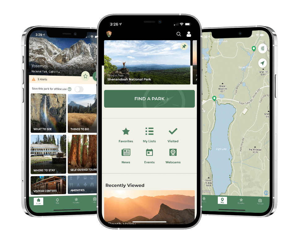
National Park Service App
The official National Park Service app is an all-in-one tool for planning a national park adventure and finding your way around the park. The app has information about every national park site across the country, essentially putting all the online information at your fingertips.
The free app features interactive maps, self-guided tours, amenities like restrooms, and lists of things to do. The powerful app has an offline mode – with a single tap, you can save the park for offline use to access all the information later. You’ll also have access to important information like alerts, contacts, fees, and operating hours.
Map of National Park Sites in Virginia
Note | This map only displays the portions of the Appalachian Trail and Potomac Heritage Trail in Virginia.
How to use this map | Click the icon in the top-left corner to open the Map Legend, then click on any of the legend items to display more information. If you have a Google account, click the (very faint) star at the end of the map’s name to save this map to your account, then access the map from your smartphone during your trip.

Harpers Ferry National Historical Park
Harpers Ferry is one of the most recognizable trail towns along the Appalachian Trail. But long before the long-distance hiking trail passed through, the town was known for an attempted slave rebellion.
Harper’s Ferry is a small town at the congruence of the Shenandoah and Potomac Rivers where Virginia, West Virginia, and Maryland meet. Although the park spans all three states, all the things to do are in West Virginia.
Pro Travel Tip | Spring, summer, and autumn are the busiest times to visit Harpers Ferry NHP. Plan to arrive early and to make the most of your time plan to spend the night somewhere nearby.
In 1859, an armed group of men led by John Brown captured the armory in the small town. They intended to give the firearms to local Virginia slaves and help them escape into the North. A detachment of Marines led by Colonel Robert E. Lee captured Brown and summarily hung him.
The Battle of Harpers Ferry in September 1862 was a resounding defeat for the United States. 12,500 Union soldiers surrounded during the battle, the largest Union defeat of the war.
Harpers Ferry National Monument was established in 1944, and redesignated Harpers Ferry National Historical Park in 1963. The 4,000-acre park preserves five Civil War battlefields, the reconstructed armory, and 20 miles of trails. It’s a popular weekend escape for Washington residents and Appalachian Trail thru-hikers.


Cedar Creek and Belle Grove National Historical Park
In 1732, German immigrant Jost Hite settled on 140,000 acres in the upper Shenandoah Valley. When his son, Isaac, married Nelly Madison, he gave the newlyweds 483 acres. Isaac Hite fought for the Patriots during the American Revolution. After the war, he built the Manor House from 1794 until 1797.
Union General Philip Sheridan briefly occupied the house during the Civil War. On October 19, 1864, Confederate Lieutenant General Jubal Early surprised Union forces marching through the Shenandoah Valley. He took 1,000 prisoners and captured several artillery pieces. But later that afternoon, Sheridan retaliated, freed the prisoners, and recaptured the artillery.
Cedar Creek and Belle Grove National Historical Park was authorized in 2002 to preserve the Civil War battleground. The National Trust for Historic Preservation owns the Manor House.
Pick up a brochure at the national park’s visitor center in nearby Middletown. A 17.5-mile self-guided driving tour includes 9 stops across the battlefield. A series of trails cross the battlefield, including the remnants of trenches built by the U.S. 19th Corps before the battle.
Take a guided tour of the Manor House to learn more about the original owners. The one-hour tour includes historical and architectural details and many rooms of the house. A restored 1918 barn houses a gift shop and additional exhibit space.

Potomac Heritage National Scenic Trail
The concept of the Potomac Heritage National Scenic Trail was established in 1983. It’s one of the three national scenic trails in the National Park System – the others being the Appalachian Trail and Natchez Trace. The trail follows the Potomac River corridor and connects many historical sites.
But it’s not a single trail. The park is more commonly called the Potomac Heritage Trail Network. It’s a confusing mess of completed, planned, wishful thinking, and alternate trails.
Following the Potomac River corridor, the network includes 710 miles of trails between the Allegheny Highlands in southern Pennsylvania and the Virginia coast.
Here are the trails in Virginia:
- Potomac Heritage Trail North is a 16-mile trail between Algonkinan Regional Park and Great Falls Park.
- Potomac Heritage Trail South is a 10-mile trail between Scott’s Run Nature Preserve and Theodore Roosevelt Island.
- Mount Vernon Trail is a 17-mile trail between Theodore Roosevelt Island and Mount Vernon.
- Northern Neck Heritage Trail is a 57-mile trail between George Washington Birthplace National Monument and Reedville at the Chesapeake Bay.
Pro Travel Tip | Visit the Chesapeake and Ohio Canal National Historical Park for information about the Potomac Heritage Trail. At this visitor center, you can collect a cancellation stamp and trail maps.

Wolf Trap National Park for the Performing Arts
In 1930, Catherine Filene Shouse began buying land traditionally called Wolf Trap because of a history of native wolves. She intended to use the land as a family retreat from their home in the Georgetown neighborhood of Washington, D.C.
Shouse had a passion for performing arts. Before the Kennedy Center existed, she donated 100 acres of the 168-acre family tract to the National Park Service as an outdoor venue. She funded the first amphitheater, opened in 1969.
In 1970, construction finished on the Filene Center. The venue features over 7,000 seats, with 3,800 under a roof and the rest spread across the lawn. First Lady Pat Nixon attended one of the earliest performances at the Filene Center.
Two 18th-century barns from Upstate New York were restored in 1981 and opened as a 382-seat theater.
In 2002, the National Park Service renamed the park to better reflect its purpose – Wolf Trap National Park for the Performing Arts. Despite the name, it is not one of the 63 national parks in the country.
The National Park Service and the non-profit Wolf Trap Foundation co-operate the park. The NPS maintains the park’s grounds while the foundation operates the performance venues.
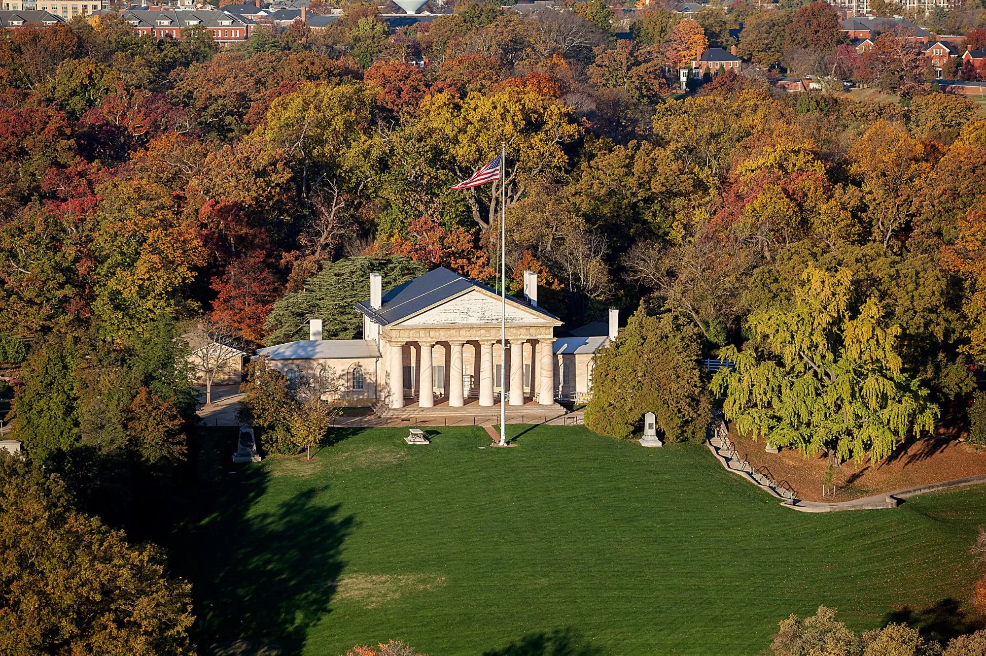

Arlington House, The Robert E. Lee Memorial
From 1803-1811, George Washington Parke Custis built a Greek Revival house at his Arlington Estate as a monument to his stepfather, George Washington. Upon his death, Custis willed the estate to his only daughter and wife of Robert E. Lee, Mary Anna Custis Lee.
Lee took a leave of absence from the army and moved to the estate to oversee restoration. Shortly after the start of the Civil War in 1861, Federal troops occupied the estate. By 1864, Mary Lee was forced to sell the plantation at auction when she could not pay the property’s taxes in person.
Seeking a burial ground for the tremendous number of soldiers killed in action, Quartermaster General Montgomery Meigs suggested using the plantation the government had just purchased at auction.
In May 1864, the first soldiers were buried at Arlington National Cemetery.
Pro Travel Tip | Visiting Arlington House requires free admission to Arlington National Cemetery. Check the cemetery’s website for details on how to get there and admission requirements.
The National Park Service received the house and 28 acres of surrounding gardens in 1933. A joint resolution of Congress in 1955 designated the “Custis-Lee Mansion” as a permanent memorial to Robert E. Lee. Finally, in 1972, Congress established Arlington House, The Robert E. Lee Memorial.
Visitors must enter through Arlington National Cemetery using either the cemetery’s parking garage or Arlington Cemetery Metro station on the Blue Line. It’s a 20-minute walk from the visitor center to Arlington House. Take a self-guided tour of the house restored with period furniture and décor from the late 1800s.


George Washington Memorial Parkway
George Washington Memorial Parkway was established in 1930, linking several historic sites connected to America’s first president. The original plan was for the parkway to stretch along the Potomac River from Great Falls Park to Mount Vernon.
Construction on Mount Vernon Memorial Highway between Mount Vernon, the family home of George Washington, and Alexandria started in 1928. It was incorporated into the George Washington Memorial Parkway, and the southern section opened in 1932.
The northern section took much longer. By the time planning started, the Capital Beltway was finished – cutting off the intended memorial parkway from Great Falls Park. In 1962, the northern section was finished between Alexandria and the Beltway.
Gravelly Point is the most fascinating place to visit along the memorial parkway. The small public park is directly beneath the flight path of landing aircraft at Ronald Reagan Washington National Airport. When the aircraft fly overhead, they are about 500 feet above the ground.
Jones Point Park is another interesting public park to visit. The Jones Point Lighthouse was built in 1855 and is the only extant lighthouse on a river in Virginia.
The 18-mile Mount Vernon Trail parallels the memorial highway from Mount Vernon to Roosevelt Island. The paved, multiuse trail is a great way to stretch your legs and enjoy the sites along the river. At Roosevelt Park, the trail continues as part of the Potomac Heritage Trail to Scott’s Run Nature Preserve.
Pro Travel Tip | There is no visitor center for the George Washington Memorial Parkway. However, you can visit the park’s headquarters at the address below to collect a cancellation stamp, pick up a brochure, and find information.


Manassas National Battlefield Park
The Battle of Fort Sumter started the American Civil War in April 1861. But then, nothing happened besides a few minor skirmishes. Near the end of July, Union Brigadier General Irvin McDowell finally succumbed to public pressure for him to march against the Confederates camped in Northern Virginia.
On July 21, 1861, the Union army, with about 18,000 unseasoned soldiers, clumsily met the Confederate army of similar size and disorder. The Battle of First Manassas was a Confederate victory – but only barely.
Over a year later, the Battle of Second Manassas was another Confederate victory. Major General Thomas “Stonewall” Jackson captured the Manassas Junction. Union Major General John Pope brought the Army of Virginia to confront this attack. He was surprised by Confederate Major General James Longstreet with his 25,000-man army – the largest assault of the Civil War.
Manassas National Battlefield Park was established in 1936 by the newly created National Park Service to preserve these historic battlefields. It’s the only park in the country with this designation.
The park is bisected by U.S. Highway 29. Fortunately, that makes it easy to reach all points within the park.
The Stone House is one of the park’s most interesting places to visit. It was built circa 1828-1848 as a tavern for wagoneers. The tavern was used as a field hospital after the two Civil War battles. The National Park Service bought the house in the 1950s and conducted a full restoration. Today, visitors can take a guided tour and see where Confederate soldiers carved their names into the upstairs floor.
The Henry Hill Visitor Center and Brawner Farm Interpretive Center have a fascinating wall-sized electronic map that replays the two Civil War battles. Watch as the tiny LEDs light up, showing Union and Confederate troop movements across the landscape.
Go for a hike on an interpretive trail, enjoy a self-guided driving tour, and return at the end of August for the annual reenactment of the Battle of Second Manassas.

Prince William Forest Park
The Chopawamsic Recreation Demonstration Area was established in 1936 to house relief camps during the Great Depression. The camps were built by the Works Progress Administration. From 1933 until 1937, area farmers were relocated to the camps – sometimes forcefully.
In 1948, Congress transferred the property to the National Park Service, and it was renamed Prince William Forest Park. It is unique in the National Park System for resembling a county park more closely than a national park.
The 15,000-acre park has 3 front country campgrounds and one in the backcountry. The Oak Ridge Campground has 100 sites for tents and RVs but no hookups. The Prince William Forest RV Campground is the park’s best, with full hookups, a private concessionaire, and an outdoor swimming pool.
The park maintained five of the original cabin camps by the Civilian Conservation Corps. Cabin Camps 1, 2, 4, and 5 are reserved for group events and can host 70-200 people. Cabin Camp 3 features solo cabin rentals for weekend getaways.
37 miles of hiking trails range from short jaunts to 9-mile excursions throughout the park. The 8-mile scenic drive is spectacular throughout the year.


Shenandoah National Park
In the 1920s, work began on Virginia’s first national park – though nobody knew it would become one at that time. Congress asked Virginia to acquire between 250,000 and 500,000 acres for a park. In 1929, Southern Appalachian National Committee member William Gregg suggested building a “sky-line drive” along the crest of mountains bordering the Shenandoah Valley.
In 1931, the Civilian Conservation Corps began work on Hoover Highway. However, the route was renamed Skyline Drive when President Franklin D. Roosevelt opened Shenandoah National Park in 1936.
The 105-mile Skyline Drive is the primary route through the national park. The road connects hundreds of scenic overlooks, wayside exhibits, and hiking trails.
READ MORE | The Ultimate Road Trip on the Skyline Drive Through Shenandoah National Park
Hawksbill Mountain is the highest peak in the park at 4,051 feet. The 1.5-mile roundtrip hike on the Hawksbill Summit Trail (bookmark on AllTrails) is one of the most popular trails in the state. But it’s also one of the most challenging with a 700-foot elevation change.
But the 6.8-mile hike (bookmark on AllTrails) to Old Rag Mountain is the most popular trail in the park. It’s become so popular that the National Park Service now requires day-use tickets to control the number of hikers. It’s a physically demanding hike with a 2,350-foot elevation change to a spectacular 360-degree view on the summit at 3,284 feet.
Rapidan Camp is an interesting place to visit. President Herbert Hoover bought the property while living in the White House. He built a cabin as a country retreat in 1929. Years later, he donated the property and buildings to the National Park Service.
The Appalachian Trail parallels the Skyline Drive for 101 miles through Shenandoah National Park. Although the national park has 500 miles of trails, the Appalachian Trail is among the most frequently hiked.
The national park includes 4 campgrounds for spending nights. Book a room at the Big Meadows Lodge or Skyline Resort if you prefer something without a tent or RV.

Fredericksburg and Spotsylvania National Military Park
Fredericksburg and Spotsylvania County Battlefields Memorial National Military Park was established in 1927 to preserve four Civil War battlefields. In 1933, the War Department transferred the unit to the National Park Service. And the name remained – at 75 characters, it’s the longest name of any unit in the National Park System.
Four Civil War battles were fought throughout the region, one of them concluding the climax of the war:
- Battle of Fredericksburg on December 11-15, 1862
- Battle of Chancellorsville on May 1-3, 1863
- Battle of The Wilderness on May 5-7, 1864
- Battle of Spotsylvania on May 8-21, 1864
The best way to explore the 8,300-acre park is a self-guided driving tour. Each battlefield has a dedicated driving tour brochure available at the Fredericksburg Battlefield Visitor Center or Chancellorsville Battlefield Visitor Center.
One of the most significant Civil War places to visit is the Stonewall Jackson Death Site. During the Battle of Chancellorsville, Jackson was wounded by friendly fire. After having his left arm amputated, he was taken to the Fairfield Plantation to await rail transport to Richmond. Eight days later, Jackson died from an infection on the plantation.
The house, built in 1828, is open seasonally for visitors. The grounds are open year-round during daylight hours.
The Ellwood Manor is another fascinating place to visit. Built by William Jones in 1790, the magnificent house was a field hospital after the Battle of Chancellorsville and Union headquarters during the Battle of the Wilderness. The park has owned the house since 1977 and offers guided tours seasonally.


George Washington Birthplace National Monument
Unfortunately, George Washington’s birthplace home no longer exists. In 1896, the War Department erected a 50-foot-tall monument on the supposed site where the house once stood.
In 1923, local women established the Wakefield National Memorial Association. The first president, Josephine Wheelwright Rust, was a descendant of George Washington’s. The group intended to buy the birthplace property and build a reconstruction of the birthplace home in time for Washington’s 200th birthday in 1932.
John D. Rockefeller Jr. bought 267 acres held in trust for the association. He donated the land after the National Park Service established the George Washington Birthplace National Monument.
Although not historically accurate, the reconstruction of Washington’s birth home was completed in 1931. Rust died just four days after turning over the deed to the National Park Service – her life’s work was complete. The house opened to the public in 1932.
The Memorial House Museum is still open to the public. Visitors can also walk through the Colonial Revival Garden, a recreation of a garden circa 1860-1940. The Washington Family Burial Ground contains the graves of many early family members. Although the Log House Tea Room and Lodge is not open to the public, the 1932 lodge built for guests is worth visiting.

Assateague Island National Seashore
Established in 1965, Assateague Island National Seashore spans 37 miles along a barrier island in Maryland and Virginia. The national seashore consists of three public areas: Assateague Island National Seashore, Assateague State Park in Maryland, and Chincoteague National Wildlife Refuge in Virginia.
In Virginia, the National Park Service operates the Tom Cove Visitor Center. The visitor center has a small gift shop, marine aquarium, and exhibits. Visitors can buy entrance passes for the park and the Over Sand Vehicle zones.
The OSV Zone extends from the visitor center to the south end of the barrier island. It’s open seasonally from September through March and offers a chance for a spectacular adventure.
The Chincoteague National Wildlife Refuge is operated by the U.S. Fish and Wildlife Service. The visitor center has information about the refuge’s hiking trails, driving tours, and wildlife. In 2004, the national wildlife refuge took possession of the Assateague Light, a lighthouse completed in 1867.
Wildlife Loop Road is a great place to see the wildlife and experience the national seashore. The one-way paved road takes about 15 minutes to drive, surrounding a small marsh with scenic overlooks and hiking trails.
Chincoteague National Wildlife Refuge is home to the famous wild ponies. Every year, the Saltwater Cowboys round up the barrier island herd and swim them across the channel to Chincoteague Island. Ponies are auctioned off to raise funds for the town’s volunteer fire department and manage the herd’s size. The annual event draws thousands of visitors.


Fort Monroe National Monument
In 1834, Fort Monroe – named after President James Monroe – was completed near the entrance to Chesapeake Bay. It was part of the Third System of Forts to protect America from naval attacks. It’s the largest stone fortress in the country, with a 1.3-mile perimeter stone wall.
During the Civil War, the fort became known as “Freedom’s Fortress” when the fort’s commander, Major General Benjamin Butler, ruled that the Fugitive Slave Act no longer applied to slaves who escaped from seceded states. Butler ruled that escaped slaves – property in the eyes of the Southern states – were contraband.
The fort was disarmed in 1946 and finally decommissioned in 2011. About a month later, President Barack Obama signed an executive order creating the Fort Monroe National Monument. The 555-acre park preserves the fort, over 200 historic buildings, and an 8-mile beach.
The Fort Monroe Visitor Center and Education Center is a 16,000-square-foot building with exhibits, a gift shop, and restrooms.
The Casemate Museum features exhibits about the fort’s military history – including the earlier Fort Algermourne, built in 1609. The museum features a special exhibit about the room where Confederate President Jefferson Davis was briefly held before being transported to Fort Jefferson – the centerpiece of Dry Tortugas National Park.
Another interesting historical figure in Fort Monroe’s history is Edgar Allan Poe. A small exhibit details Poe’s brief military history under an assumed name – and his eventual dismissal because he spent all his time writing.
Did You Know | Poe was stationed in several places during his short military career. One of his longest tenures was at Fort Moultrie on Sullivan’s Island, South Carolina. Several streets in the beach town are named after Poe’s poems.

Colonial National Historical Park
In 1930, Congress authorized a national monument to preserve the site of the Jamestown Settlement and Battle of Yorktown. Six years later, the park was redesignated as Colonial National Historical Park. The park and historical sites are co-owned and operated by an interesting agreement between the National Park Service, Preservation Virginia, and the Jamestown-Yorktown Foundation.
Established in 1607, Jamestown was the first permanent English settlement in the Americas. The Jamestown Settlement is a living history museum preserving the landscape and several buildings. The museum includes a recreation of the 1610 Fort James and a full-size replica of the Susan Constant, a 120-ton sailing vessel that brought the original colonists to the New World.
The American Revolution Museum at Yorktown is another living history museum that tells the complete story of the Revolutionary War. Indoor exhibits include an impressive museum and The Siege of Yorktown orientation film. Outside, explore a recreation Continental Army encampment and watch demonstrations.
The Yorktown Battlefield preserves the site where British General Lord Cornwallis surrendered to General George Washington in 1781, effectively ending the Revolutionary War. The historic site features the 1724 Thomas Nelson House and the Moore House, where the surrender occurred.
The National Park Service built a 23-mile scenic route connecting the two historic sites. Colonial National Historical Parkway is a two-lane limited-access road with several scenic overlooks and monuments. In 2023, a length rehabilitation began to repair several bridges and tunnels and improve the tunnel lighting to provide “a better experience for drivers, who can enjoy the views instead of dodging potholes.”
Pro Travel Tip | Buy the Four Site Value Ticket to save money on individual admissions. The pass includes admission for one person to the Jamestown Settlement, Historic Jamestowne, Yorktown Battlefield, and the American Revolution Museum at Yorktown.

Richmond National Battlefield Park was established in 1936 to preserve 13 Civil War sites around Richmond – the capital of the Confederate States of America. The park offers free admission to various sites, but you must pay for parking at some parking areas.
Tredegar Iron Works is one of the park’s most fascinating places to visit. During the Civil War, the factory provided half of the artillery for the Confederate Army. The American Civil War Museum tells how the war affected everyone in the country – not just Southerners or soldiers. The museum preserves the ruins of the foundry.
Three visitor centers provide information about the sprawling park – Cold Harbor, Chimborazo Medical Museum, and the Shelton House at Rural Plains. Learn about the Overland Campaign, Siege of Petersburg, and Seven Days Battle.

Maggie L. Walker National Historic Site
Maggie Lena Walker was a fascinating woman who transformed her small Richmond neighborhood in the early 1900s. In 1902, she established a local newspaper. The following year, she became the first African American woman to establish a bank when she opened St. Luke Penny Savings Bank.
In 1904, she bought a Victorian Gothic rowhouse in downtown Richmond. Built in 1883, the beautiful was home for her and her family for nearly eighty years. When the Maggie L. Walker National Historic Site was established in 1978, her descendants sold the Maggie Walker House to the National Park Service.
Guided tours of the historic house are offered seasonally.


Petersburg National Battlefield
Richmond and Petersburg were the center of a Union campaign during the Civil War from June 1864 until March 1865. As the Confederate States of America’s capital, capturing Richmond was vital to ending the bloody war between the states.
After 70,000 casualties and the fall of Richmond to Union forces, Confederate General Robert E. Lee surrendered on April 9, 1865.
Petersburg National Military Park was established by the War Department in 1926. In 1933, the park was transferred to the National Park Service, and in 1962 redesignated the Petersburg National Battlefield.
Grant’s Headquarters is the most popular place in the sprawling park. Visitors can stroll along trails and read wayside exhibits open during daylight hours. The park is at City Point, a critical supply port for the Union’s campaign.
The Eastern Front portion of the park has 10 miles of trails and a 4-mile road tour. The unit preserves the Fort Stedman Battlefield and Crater Battlefield. The primary visitor center for the park is in the Eastern Front.


Appomattox Court House National Historical Park
On April 9, 1865, the Army of Northern Virginia, under the command of General Robert E. Lee, surrendered to General Ulysses S. Grant at the McLean House in Appomattox Court House. The surrender ended the bloody Civil War that consumed the nation for four years.
Congress authorized a national historical monument in 1935. The McLean House, built in 1848, was disassembled and transported to Chicago for the 1893 World’s Columbian Exposition – and it never returned. After over fifty years, the house was returned, restored, and reopened to the public in 1945.
In 1954, the park’s name was changed to Appomattox Court House National Historical Park.
In 1964, the courthouse was rebuilt and serves as the park’s visitor center. The 17-minute orientation film With Malice Toward None introduces visitors to the park’s significance. Pick up a brochure before leaving and then explore one of the park’s hiking trails ranging from 1 to 4.8 miles.

Booker T. Washington National Monument
Booker T. Washington was born into slavery in 1856 on a Virginia tobacco plantation. Freed after the Civil War, Washington became the first member of his family to attend college. At 21, he was hired as the president of the Normal School for Colored Teachers in Tuskegee, Alabama.
In 1956, Congress designated the Booker T. Washington National Monument on 207 acres of the tobacco plantation where he grew up. The site preserves the farm, interprets Washington’s life and accomplishments, and shows what life was like on an 1850s slave farm.
The visitor center has an orientation film about Washington. Pick up a brochure to learn about the various trails in the park. The .25-mile Plantation Trail meanders through a reconstruction of the 19th-century Burroughs Plantation.


Blue Ridge Parkway
During the construction of Shenandoah National Park and Great Smoky Mountains National Park, Virginia Senator Harry F. Byrd pitched an idea to President Roosevelt: build a scenic highway connecting the southeast’s first two national parks. Initially called the Appalachian Scenic Highway, when Congress authorized the project in 1936, it was called the Blue Ridge Parkway.
Construction began under the Works Progress Administration. But work was slow during the Great Depression and WWII. By 1966, all but 7.7 miles were finished. The final section, infamously dubbed “The Missing Link,” was a tricky maneuver around the slopes of Grandfather Mountain in North Carolina.
Read More | 6-Day Road Trip on the Blue Ridge Parkway
When the Linn Cove Viaduct opened in 1987, the 469-mile Blue Ridge Parkway was completed – 52 years after construction began. The parkway features breathtaking views along the ridge, connecting historic places of interest, hiking trails, and scenic overlooks.
215 miles of the Parkway pass through Virginia between Galax and Waynesboro. At the northern terminus, the road continues onto the Skyline Drive through Shenandoah National Park.
Here are some of the best overlooks and places to visit on the Blue Ridge Parkway in Virginia:
Website | www.nps.gov/blri


Appalachian Trail
In 1922, forester Benton MacKaye conceived of a series of trails throughout the Appalachian Mountains from Georgia to Maine. The trails would give “city dwellers” an opportunity to experience the wonderment of nature. In 1924, a trail club in New York completed the first 21-mile section.
The Appalachian Trail Conservancy was founded in 1925 in Washington, D.C. The non-profit organization’s initial objectives included adding the iconic white blazes along the trail and coordinating the dozens of independent trail building projects. When the trail was completed in 1937, the organization’s objectives shifted to maintaining and promoting the trail.
In 1938, the Appalachian Trail was transferred to the National Park Service, although the NPS has nothing to do with maintaining the trail. The NPS and ATC created a partnership – the trail is protected on federal land and maintained by the non-profit organization.
538 miles of the Appalachian Trail pass through Virginia – more than any other state and nearly a quarter of the entire trail. 107.5 miles of the trail passes through Shenandoah National Park, offering plenty of day trip hikes and overnight excursions near convenient parking.
Bookmark on AllTrails | Appalachian Trail in Shenandoah National Park
Here are some additional highlights of the Appalachian Trail in Virginia:
- Buzzard Rock on Whitetop Mountain at Mile 483.6
- Mount Rogers at Mile 490.6– the highest point in the state
- Grayson Highlands State Park at Mile 493.9
- Angels Rest on Pearis Mountain at Mile 623.4
- McAfee Knob at Mile 702.5 – one of the most popular hikes in the state
- Apple Orchard Falls at Mile 758
- Blackrock Summit at Mile 873


Cumberland Gap National Historical Park
In 1775, Richard Henderson met with Cherokee leaders in Elizabethton, Tennessee, to negotiate North America’s largest private land transaction. The Transylvania Purchase gave eager settlers access to most of eastern Kentucky. Although the treaty was immediately denounced by Virginia authorities, it didn’t stop the westward expansion.
The company hired Daniel Boone to blaze a trail into Kentucky. Boone discovered a route through the mountains that would be best for heavily loaded wagons. The “Wilderness Road” crossed through the Cumberland Gap, later dubbed the “Gateway to the West.”
When President Franklin D. Roosevelt signed the legislation creating Cumberland Gap National Historical Park in 1940, he said it was to “commemorate the story of the first doorway to the West.” The 14,000-acre park opened in 1959.
The visitor center in Middlesboro, Kentucky, has a great museum and gift shop. Watch the 23-minute Daniel Boone and the Westward Movement or 11-minute The Cumberland Gap orientation films to learn more about the area.
Pinnacle Overlook is one of the best scenic overlooks in the southeastern United States. The overlook is perched above the gap on the side of the mountain. Along the 0.2-mile walk from the parking lot, you’ll cross the boundary between Kentucky and Virginia.
Burton Hensley bought 200 acres on Cumberland Mountain in 1900. He divided the land into lots and sold them to eager settlers. A community of 100 people prospered until the late 1940s. Sherman Hensley was the last to leave in 1951. It’s about a 10-mile hike from the Pinnacle Overlook parking lot to the settlement.
Other popular hikes include Skylight Cave and Gap Cave. The Wilderness Road Trail begins in Cumberland Gap, Tennessee. The short trail passes through the reconstructed gap in the mountains. A marker on the trail shows where Tennessee, Virginia, and Kentucky meet.
Frequently Asked Questions
Shenandoah National Park stretches 105 miles between Front Royal and Waynesboro on the eastern side of Shenandoah Valley.
There is only one “national park” in Virginia – Shenandoah National Park. However, there are 22 national park sites.